

Equatorial coordinates


Like altazimuth coordinates ecliptic coordinates, equatorial coordinates are an orthogonal spherical reference system, i.e., in which the two series of circles selected to fix the position of a point on the celestial sphere intersect at right angles.
Like ecliptic coordinates, equatorial coordinates are based on celestial references and are thus, in a first approximation, linked to the fixed stars. This means that the two angles used to identify a celestial body—right ascension and declination—are identical for all terrestrial observers.
Of the three traditional reference systems, the equatorial coordinates were the last to be introduced. Claudius Ptolemy (2nd C. C.E.) describes the "system of the right sphere" based on equatorial coordinates alongside the "system of the oblique sphere" based on ecliptic coordinates. But the practical superiority of the equatorial system in celestial surveying was not defended until Reiner Gemma Frisius (1508-1555) in 1534. The simplifications made possible by equatorial coordinates in surveying instruments and the improved mathematical expertise that facilitated the transformation of coordinates between periods convinced the great Danish astronomer Tycho Brahe (1546-1601) to use equatorial coordinates in observations. Since his day, equatorial coordinates have gained very widespread acceptance.
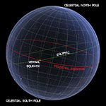
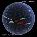
The main great circle of reference of the equatorial coordinates is the celestial equator, which gives them their name. It is also called equinoctial circle, or more concisely equinoctial, because it carries the two diametrically opposite points of the equinoxes.
In geocentric astronomy, the celestial equator was defined as the locus of the points of the celestial sphere equidistant from the celestial poles. Only in the modern heliocentric system does it represent the projection of the terrestrial equator on the celestial sphere.
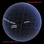
The main axis of reference used in equatorial coordinates is the straight line passing through the observer and perpendicular to the plane of the celestial equator. It is called polar axis or axis of the heavens because it intersects the celestial sphere in two points: the celestial north pole and the celestial south pole.
In the modern heliocentric system, the polar axis is merely an imaginary straight line parallel to the axis of the Earth's rotation. But in geocentric astronomy, it was an objective reality. The celestial poles were the immobile pivots of the sky, around which the crystal spheres of the planets and the fixed stars completed a full revolution in about 24 hours.
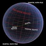
Each of the circles that can be plotted on the celestial sphere parallel to the celestial equator is called a declination parallel, from the name of the coordinate—declination—that gives its distance from the equator. These circles form the set of parallels of the celestial sphere in the equatorial-coordinates reference system.
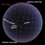
Each great circle intersecting the celestial poles is called an hour circle. The set of hour circles constitute the meridians of the celestial sphere in the equatorial-coordinates reference system.
They owe their name to a practical mathematical relationship. Since the celestial sphere and the stars seem to uniformly complete a revolution from east to west in about 24 hours, the angle of separation between two hour circles, measured on the celestial equator and ranging between 0° and 360°, can be linked to a "stellar" or "sidereal" time ranging between 0 and 24 hours. By measuring the angle between two hour circles, we can therefore determine the sidereal time that will elapse before the rotation of the celestial sphere takes the more eastward hourly circle to the position initially occupied by the more westward hour circle.
The first of the two equatorial coordinates is called right ascension (from the medieval contraction of the expression ascension in the right sphere). It is the angle computed from west to east on the celestial equator from the vernal equinox up to the intersection of the hour circle of the celestial body with the celestial equator.
Until the seventeenth century, right ascension was usually measured in degrees (from 0° to 360°) and fractions of degrees. Later, a measurement in hours, minutes, and seconds became the standard practice. In fact, it should be remembered that, while the celestial sphere appears to complete its revolutions around the celestial poles in uniform periods of about 24 hours, it will rotate by about 1° every four minutes. The difference in right ascension between two celestial bodies therefore defines either (1) the angular distance between the two celestial bodies relative to the celestial equator, or (2) the sidereal time elapsed between the crossings of the local meridian by the first and second celestial bodies.
The second of the two equatorial coordinates is called declination and consists of the angle subtended by the arc of hour circle separating the celestial body from the celestial equator. Declination is measured between 0° and 90° and the minimum and maximum values are reached on the celestial equator and at the celestial pole respectively. Also, the declination is positive (north) or negative (south) depending on whether the celestial body is located in the northern or southern hemisphere.
Astronomical declination must not be confused with magnetic declination, which, for the compass, denotes the angle—varying from place to place—between the direction of the magnetic pole and that of the geographic pole.