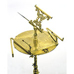
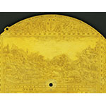
This surveying instrument consists of a circular plate whose rim carries a Latin inscription explaining its use "for operations of Geography, Corography and Cartography." The instrument's functions are finely illustrated in an engraving that fills the upper half of the plate, where some surveyors can be seen at work in front of a landscape. The lower half of the plate is occupied by a shadow square, a half windrose with a degree scale, and a geographic planisphere. The whole is contained in a square inscribed in the plate's circumference, and divided into 200 parts per side. The upper side of the square is inscribed with the maker's initials "BL" (Baldassarre Lanci), whose full name, together with the date 1557, appears on a rectangular block mounted on the base of the square. This element has a fixed lower part whose right end carries a folding arm with sights, divided into 400 parts, and an upper sliding part whose left end carries a folding arm identical to the previous one. Below the block was a small magnetic compass of which only the housing survives. At the center of the plate pivots a small column that bears a sliding needle surmounted by a tube sight that can be adjusted vertically as well as horizontally.
The instrument was used for measuring distances and heights, for surveying and—thanks to the central element—for making perspective drawings. These were made on a small curved table (now missing) lodged in the three holes visible along the rim of the disk. The instrument's use for the latter task is recorded by Daniele Barbaro in La pratica della perspettiva [The practice of perspective] (Venice, 1569) and by Egnazio Danti in his commentary on Jacopo Barozzi from Vignola's Le due regole della prospettiva [The two rules of perspective] (Rome, 1583). Provenance: Medici collections.


